Logo
Home About News Data Internet Mapping Training Directory State Activities Products Links

Menu
About the Center
GIS News
GIS Data
Internet Mapping
Training and Education
State GIS Directory
State GIS Activities
Products
Links


MapWV.gov


GeoData.gov


Got a hot news item? Submit it!


Would you like periodic updates from the site? Subscribe here!


The National Map

The National Map is envisioned by the USGS as a seamless, continuously maintained, and consistent set of online, public domain, core geographic data. The National Map will serve as a foundation for integrating, sharing, and using other government and private sector data easily and consistently. Eight primary data layers constitute The National Map: digital orthorectified imagery, elevation, hydrography (water), transportation, boundaries, cultural features, geographic names, and land cover.

Eastern Region Geography Draft Strategic Plan (April 2004, PDF format)

The National Map State Business Plan (Feb. 2004, PDF format)

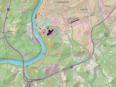
West Virginia's "Future" Topographic Map: A National Map Pilot (Nov. 2003, PDF)
Morgantown South, WV, 7.5-Minute Quadrangle (Nov. 2003, PDF, 11.5 MB)
(click for larger image)


Home About News Data Internet Mapping Training Directory State Activities Software Links

Questions? Comments? Contact Us!

Page Copyright ©2000 West Virginia University All Right Reserved. ESRI and the ESRI Logo are licensed trademarks of Environmental Systems Research Institute, Inc. Please check our Terms of Use for rules and regulations with regard to our datasets.