How Do I Use Web Services?

The WV GIS Technical Center publishes serveral ArcGIS Rest Services for use by the general public. To access our rest services, either point your ArcCatalog or your web browser to: http://services.wvgis.wvu.edu/ArcGIS/rest/services

For more information concerning adding web services to ArcGIS 10.1, please see ArcGIS Help on the topic. For other pieces of software, please see the help for the particular software. If your software does not support ArcGIS Rest Services, please see our data clearinghouse to download individual files of datasets.

What File Formats Are Supported by the Tech Center?

FILE FORMAT


Definition:

Notes on Use:
Due to the large amount of data involved, all files are archived and compressed into a single zip file for easy downloading. Single-precision coverages can store up to seven significant digits for each coordinate, double-precision coverages up to fifteen significant digits.

File TypeExtensionName
Vector
*.shp
*.e00
*.dlg
ArcView Shapefiles (*.shp, *.shx, *.dbf)
Arc/Info Export files
USGS DLG Optional
Image
.tif/.tfw
*.tif
*.img
INFO folder
TIFF (Tag Image File Format / World File)
GeoTIFF (TIFF with Geo header)
IMAGINE (ERDAS IMAGINE)
ArcInfo GRID (ESRI Grid File)
Compression
*.sid

*.zip
MrSID (Multiresolution Seamless Image Database)
Zip files (.zip)

What Coordinate Systems Are Used by the Tech Center?

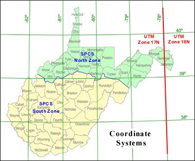
The Geodetic Control / Surveying Task Force recommended to the WV GIS Steering Committee that all agencies mapping geographic data within West Virginia utilize one of the following three coordinate systems: Geographic Coordinate System, Universal Transverse Mercator, or State Plane Coordinate System, all referenced to the North American Datum of 1983. Only these coordinate systems and datum will serve as the official data exchange standard for GIS data sets that make up the West Virginia Spatial Data Infrastructure. In August 2002, the new standard was approved by the WV GIS Steering Committee.


West Virginia Coordinate Systems

Typically three coordinate systems are utilized in West Virginia:
  1. Geographic (Latitude/Longitude) for general referencing and data distribution
  2. Universal Transverse Mercator (UTM) for statewide GIS data sets
  3. State Plane Coordinate System (SPCS) for countywide data sets
File name extensions reflect the type of coordinate system.

Coordinate System Projection WV Zones Map Units File Extensions
Geographic (Latitude/Longitude) None None Decimal Degrees LL83 (NAD 83)
LL27 (NAD27)
Universal Transverse
Mercator (UTM)
Universal Transverse
Mercator (UTM)
17N and 18N Meters UTM83 (NAD83)
UTM27 (NAD27)
State Plane
Coordinate System (SPCS)
Lambert
Conformal Conic
North and South Feet SPN83 (North Zone, NAD83)
SPS27 (South Zone, NAD27)