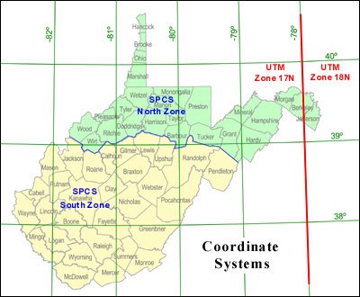
The Geodetic Control / Surveying Task Force recommended to the WV GIS Steering Committee that all agencies mapping geographic data within West Virginia utilize one of the following three coordinate systems: Geographic Coordinate System, Universal Transverse Mercator, or State Plane Coordinate System, all referenced to the North American Datum of 1983. Only these coordinate systems and datum will serve as the official data exchange standard for GIS data sets that make up the West Virginia Spatial Data Infrastructure. In August 2002, the new standard was approved by the WV GIS Steering Committee.
| Coordinate System | Projection | WV Zones | Map Units | File Extensions |
|---|---|---|---|---|
| Geographic (Latitude/Longitude) | None | None | Decimal Degrees | LL83 (NAD 83) LL27 (NAD27) |
| Universal Transverse Mercator (UTM) |
Universal Transverse Mercator (UTM) |
17N and 18N | Meters | UTM83 (NAD83) UTM27 (NAD27) |
| State Plane Coordinate System (SPCS) |
Lambert Conformal Conic |
North and South | Feet | SPN83 (North Zone, NAD83) SPS27 (South Zone, NAD27) |